
Guides
Vacation homes sales 2027: how remaps raise costs
Vacation homes sales 2027 hinge on flood and fire map revisions, because a new zone changes insurance, mortgage and disclosure costs for a property.
What to take away
- A remap changes the rules that apply to future work, and usually leaves an existing lawful building alone until work is proposed.
- The trigger that matters is not the map adoption but the point at which someone applies to build, extend or substantially repair.
- Revisions are public processes with comment periods, and the preliminary version is available long before it takes effect.
- For 2027 vacation home sales, the map effect arrives through insurance, mortgage and disclosure costs, not through a change in the dirt.
Vacation homes sales 2027 will hinge on flood and fire maps now in revision. A remap can move a house into a special flood hazard area or a high fire severity zone. That changes insurance, mortgage and disclosure costs. It does not change the dirt or the view.
The sales link is cost. FEMA's Risk Rating 2.0 has pushed National Flood Insurance Program premiums toward risk-based rates. FEMA materials put the average full-risk premium for a single-family home near $1,800 a year, with most existing policies capped at an 18% annual increase.
Lenders require flood insurance for federally backed mortgages in a mapped Special Flood Hazard Area. That is the mandatory purchase requirement, written into the Flood Disaster Protection Act of 1973 and carried out through lender guidelines from Fannie Mae and Freddie Mac. That added annual cost can cut what a buyer will pay. First Street Foundation, CoreLogic and ATTOM all publish parcel-level flood or fire risk scores that buyers and agents can check before a showing.
Fire maps work through insurance and disclosure. CAL FIRE's Fire Hazard Severity Zones classify land as moderate, high or very high, and the state publishes the maps county by county. California sellers must disclose a high or very high designation on the Natural Hazard Disclosure Statement, the form that state law — Civil Code section 1103.2 — requires at transfer.
Insurers use those zones, plus their own models, to decide whether to renew a policy. As of 2026, annual premiums in high fire areas often run from about $3,000 to $6,000. California's FAIR Plan writes fire-only coverage, and its rates can exceed admitted-market rates. In flood, private carriers and surplus-lines markets — Chubb and Lloyd's of London among them — now write coverage that competes with the National Flood Insurance Program.
No official count of 2027 vacation home sales exists yet. The National Association of Realtors tracks the category. Its Investment and Vacation Home Buyers Survey reported about 1.13 million vacation home sales in 2021, the pandemic peak. Later editions showed a sharp slowdown. Vacation homes have lately run around 5% to 7% of existing-home transactions.
For 2027, watch three numbers: the share of listings in a revised flood or fire zone, the quoted insurance premium, and the buyer's monthly payment.
NAR's public 2026 outlook put total existing-home sales in the mid-4 million range. It did not break out vacation homes by hazard status. Zillow, Redfin and Realtor.com let buyers filter by flood or fire risk in some markets. That lets a buyer compare two similar homes with different map status.
This guide explains what a map revision does and does not do to an existing property, how the insurance and disclosure costs land on a vacation home or short-term rental, and how to follow a revision while it is still in progress.
What a flood or fire map revision actually is
A flood or fire map revision starts with a study. Flood zones come from hydraulic and hydrologic modeling. Fire zones come from fuel and terrain modeling. Coastal zones come from elevation and inundation modeling. Each study is a snapshot of method and data.
When the data improves, the modeled zones move. High-resolution elevation data replacing older survey is the most common reason. A parcel outside a mapped zone can land inside it, or the reverse. Nothing physical changed on adoption day. A set of requirements did.
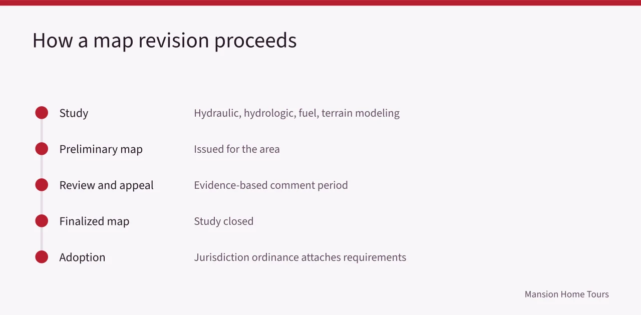
The revision then goes through an administrative process. A preliminary map is issued. There is a period for review and appeal. The map is finalized, and the jurisdiction adopts it. Requirements attach at adoption.
Two underlying data sources are worth knowing directly. Elevation and terrain products come through the National Map, and the high-resolution ground surface that drives most modern remapping is lidar, described at what lidar data is and where to get it. For coastal inundation scenarios specifically, the NOAA sea level rise viewer publishes the scenario mapping openly.
What changes for an existing building
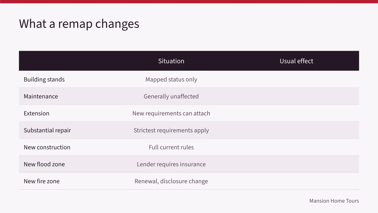
| Situation | Usual effect of a remap |
|---|---|
| Building stands, no work proposed | Generally none in construction terms; the mapped status changes |
| Ordinary maintenance | Generally unaffected |
| Extension or alteration | New requirements can attach, sometimes to the whole building at a threshold |
| Substantial repair after damage | This is where the strictest requirements usually apply |
| New construction on the parcel | Full current requirements apply |
| New flood zone designation with a federally backed mortgage | The lender requires flood insurance; the premium comes from NFIP or a private insurer |
| New high fire severity zone | Insurance renewal and state disclosure can change; construction rules may follow |
The row that surprises people is substantial repair. Many regimes set a threshold. Repairing a damaged building above that threshold triggers compliance with current standards for the whole structure. The purpose is to avoid locking in the hazard for another generation.
Map status can change a sale even when no work is proposed. A new Special Flood Hazard Area designation can add a federal flood insurance requirement for a mortgage. A new high fire severity zone can affect renewals and disclosure. Both can shift the buyer pool for a vacation home.
What a remap means for a short-term rental
For a short-term rental, a remap shows up in the operating cost rather than the walls. A property that lands in a Special Flood Hazard Area needs flood coverage on the mortgage, and a property newly inside a high fire severity zone can face questions at renewal. Either one moves the cost of holding the unit, which is the number a vacation home buyer is underwriting for 2027.
Following a revision
- Find the agency running the study and its published schedule for the area. For flood maps, that is FEMA's Risk MAP program and the FEMA Flood Map Service Center. For fire, it is often a state forestry agency such as CAL FIRE.
- Get the preliminary map, not just the effective one. The preliminary version shows what is coming.
- Read the comment and appeal process. Appeals are generally evidence-based, which means better data rather than objection.
- Watch for the local adoption step. The jurisdiction's ordinance is what actually applies.
- Re-check, because schedules move.
The layers themselves are public. FEMA's Flood Map Service Center publishes both the effective and the preliminary panels for a parcel, and reading those panels — zone letters, base flood elevation, panel date — is the first step in sizing the risk. For fire, CAL FIRE publishes its Fire Hazard Severity Zone maps for each county.
None of it becomes a rule until a jurisdiction adopts the map into its own code, usually through the ordinance that administers floodplain or fire-safe standards. An owner or buyer who wants the answer for one parcel should ask that building department and the mapping agency directly.
Common questions
If a map changes, does my building become illegal?
No. A lawfully built building that no longer complies with a new requirement is generally a legal nonconforming condition. What changes is what happens when work is proposed.
Can a mapping decision be challenged?
There is usually a defined appeal process, and it turns on technical evidence: better elevation data, a corrected model input, a survey. During a revision, comments and appeals go to the agency running the study; once a map is effective, an owner can ask FEMA for a Letter of Map Amendment or a Letter of Map Revision based on a survey.
Why do the maps keep changing?
Because the data keeps improving and the modeled conditions themselves change. A map that never changed would be a map nobody was maintaining.
Will 2027 vacation home sales fall because of remapping?
No single number answers that. Sales depend on mortgage rates, inventory and local incomes as much as maps. The map effect shows up in insurance quotes, disclosure forms and mortgage approvals for individual properties. NAR's vacation home share and the insurance quotes on a specific parcel are the numbers to watch.
Where do I check what applies to a specific place?
The jurisdiction's building department and the mapping agency's own current publication for that area. Any other source, including this page, is orientation rather than authority.